Put together a .kmz file with waypoints from my paddle from Gustavus to Sitka. These are mostly campsites, but a few other points of interest as well. Available here.
Wednesday, December 20, 2017
August 11-13: Brent's Beach to Sitka, then back to Juneau
It's always a little anticlimactic to end a beautiful trip, and this trip, at the end of such a varied, beautiful summer, was no exception.
Concerns about incoming stormy weather got us on the water relatively early, and our paddle to Starrigavan Bay, on the North end of the Sitka road system, was uneventful. We planned to stay at the Starrigavan USFS campground, which is pretty and well maintained, with sites right on the water. It's also a very short paddle to the ferry terminal, though the campground is a little rustic, with no showers or other services.
The campground gets cellular reception (actually, we also had reception the night before, at Brent's Beach), so it was easy to call a taxi for a ride into town. We stopped at the local laundromat for showers, which put us within easy walking distance of downtown Sitka, with pizza and ice cream, and very good Mexican food, among other treats. It was good to be eating pie at the Sitka airport when the wind started to blow.
I was a little heartsick to learn that I had mis-remembered the ferry schedule, and as a result wound up missing an afternoon ferry on the 11th, which would have gotten us home that same day. The result was an couple of unnecessary nights in Sitka; always a lovely place to spend time, though I was itching to be home after all summer away. Mostly to kill time, we took a short paddle into Katlian Bay on the 12th, then more Mexican food.
Made it home to Juneau on the 13th, after a 10 hour ride on the M/V Matanuska. An infrequently used boatyard next to the Sitka ferry terminal has twice now been a landing spot at the end of trips like these--easier to paddle from the campground to the ferry terminal then carry gear for a half mile on the road, so we risked the chance that we might be trespassing. Pancakes and greasy bacon on the ferry, then a nap in the solarium.
It was good to be home.

Sunday, December 17, 2017
August 10: Leo Anchorage to Brent's Beach
With weather forecasts still predicting strong Southerlies for the afternoon of the 11th, we were happy to be near the end of our outside coast stretch. I was a little sad to give up on my hope of a trip extension around the outside of Kruzof Island, and although Jason and Christian would rather the trip was longer overall, I think we were all pretty happy to have experienced such exceptional weather on such a beautiful stretch of coastline.
With one relatively exposed section remaining, we headed out of Leo Anchorage under glassy conditions, quickly turning into Salisbury Sound, where were pushed in by moderate West winds that strengthened to perhaps 15 knots by late morning. We stopped and took a lunch break at the mouth of Sukoi Inlet, near Sukoi Point, then headed back into protected waters once more. I remembered being struck by the austere beauty of the area the previous time I had paddled in Salisbury Sound--also with Jason--two summers prior. Now, by comparison with what we had paddled through, it all seemed quite tame.
Although it is possible to paddle into Krestof Sound from Sukoi Inlet, the Southern end of the inlet dries at low tide, and was only a few feet deep when we paddled through, quite near high. At one point, we startled a land otter near the bank, who dove into the water and swam directly under my kayak, clearly visible in the shallow water. A few minutes later, we watched an eagle snatch a small pink salmon from the water in front of us, and not forty minutes after that, we surprised a brown bear swimming across the channel.
Fading in the heat, with the sun beating down and no wind, we paddled towards, then through the Magoun Islands, searching for a campsite. By that time, we were in easy striking distance of Sitka the next day and every additional mile was a bonus. We debated camping near Point Brown, at the entrance to Sitka Sound, but decided to push on to Brent's Beach, where there is another Forest Service cabin. We arrived to find the cabin empty, and although we worried we might be disturbed by paying visitors from Sitka, we were undisturbed. A good thing, since good tent sites near the cabin were in short supply.
 |
| Tame scenery and hats near Sukoi Pt. |
 |
| Paddling down Sukoi Inlet |
Fading in the heat, with the sun beating down and no wind, we paddled towards, then through the Magoun Islands, searching for a campsite. By that time, we were in easy striking distance of Sitka the next day and every additional mile was a bonus. We debated camping near Point Brown, at the entrance to Sitka Sound, but decided to push on to Brent's Beach, where there is another Forest Service cabin. We arrived to find the cabin empty, and although we worried we might be disturbed by paying visitors from Sitka, we were undisturbed. A good thing, since good tent sites near the cabin were in short supply.
 |
| Brent's Beach |
August 9: Drip Point to Leo Anchorage
 |
| South of Khaz Head |
However, before heading out to open water, we needed to fill up our water supplies, which were running quite low. We found a small cove N of Khaz Head with a little stream, but our refill took some time--we should have planned better and taken a break for water the day before.
 Even so, we made good time and had little trouble with weather. Swells were predicted for 5', and even close to shore, with depth effects, were probably no more than that. Overall, quite pleasant, with another Northerly to speed us along.
 The paddle was mostly uneventful, and we made the protected area around Leo Anchorage by late afternoon. There, we found a lovely campsite which has obviously been frequently used. NE of Fortuna Strait, a small islet is joined to Chichagof I. by a gravel and cobble tombolo. On the Chichagof side, the established campsite has a fire ring and driftwood benches.
After pulling out and setting up camp, I took the opportunity to test paddle Christian's Avocet--a bit slower than my kayak, but easier to turn and roll. Quite a roadster.
 |
| Looking Northwest from Leo Anchorage, watching the Seine Fleet head home. |
August 8: Greentop to Drip Point
By the 8th, marine weather forecasts were predicting the end of the unbelievably good stretch of weather we had been experiencing since at least the 2nd. With a few more days of good weather, but a series of fronts coming through after that, I was nervous that we might get caught on the outer coast for some indeterminate amount of time. And after a number of relatively short days, I was itching to put in a few miles.
We said our goodbyes mid-morning on the 8th, after packing up and cleaning out the cabin, then headed out of Greentop Harbor, across the mouth of Lisianski Strait, and across Islas Bay into White Sulphur Hot Springs, where there is a Forest Service cabin and a covered enclosure over the hot springs. Jason and Christian had a good soak while I, ambivalent about hot tubbing in that day's 70-degree weather, heated up some water to rehydrate chili for dinner. All for the best, since we needed somebody to watch the kayaks as the tide rose.
In the end, I decided to jump in for a quick dip and a scrub, then a quick jump into the tepid ocean where the hot springs water ran into the salt. Felt human again, drying in the sun, though it did make putting my grungy sweatpants and shirt back on a little bit of a moral challenge.
After our stop at the hot springs, we pushed on, paddling outside of Hill Island, assisted by a growing Northerly. We made good time to Imperial Passage, where we pulled into a sheltered slot beach, startling a lone Sitka Blacktail as paddled in. There, a quick snack break, then East into Portlock Harbor, then Surveyor passage. In these sheltered areas, it was easy to forget the 4' swell outside. Plenty of sea otters and seine boats throughout.
As we neared the Northern end of Ogden Passage, we started looking, unsuccessfully, for a campsite. What we saw was mostly uneven and rocky. We found a pleasant site at Drip Point, however, which is on a small island with a North-facing beach, and a smaller beach just S of the point, with a SW aspect. Here, we found good tent sites and a convenient place to pull out.
One of the things I learned this summer is that I don't eat as much as I think I do--my meal plan is always a little skimpy by the standards of my paddling partners. Par for the course, my chili dinner, planned for that evening, turned out to be a little underpowered for Jason and Christian, so we served it over a helping of mashed potatoes, which turned out to be a dynamite combination.
 |
| Snack break at Imperial Passage |
In the end, I decided to jump in for a quick dip and a scrub, then a quick jump into the tepid ocean where the hot springs water ran into the salt. Felt human again, drying in the sun, though it did make putting my grungy sweatpants and shirt back on a little bit of a moral challenge.
 |
| Jason and Christian looking spicy |
As we neared the Northern end of Ogden Passage, we started looking, unsuccessfully, for a campsite. What we saw was mostly uneven and rocky. We found a pleasant site at Drip Point, however, which is on a small island with a North-facing beach, and a smaller beach just S of the point, with a SW aspect. Here, we found good tent sites and a convenient place to pull out.
One of the things I learned this summer is that I don't eat as much as I think I do--my meal plan is always a little skimpy by the standards of my paddling partners. Par for the course, my chili dinner, planned for that evening, turned out to be a little underpowered for Jason and Christian, so we served it over a helping of mashed potatoes, which turned out to be a dynamite combination.
 |
| Cooking dinner at Drip Point, enjoying the evening light. |
Tuesday, December 12, 2017
August 7: Bohemia Basin to Greentop
 Another relatively short day paddling down Lisianski strait, mostly helped by an outgoing tide, and into Greentop harbor, followed by some visiting. Nothing especially notable, except for the beautiful scenery of the outer coast, and the confusing though pretty labyrinth of Greentop harbor.
 At one time, Greentop was a cannery town. Never very big, it currently has a few seasonal residents and a Forest Service cabin. The cabin can be reached from Greentop Harbor, but in foul weather can also be accessed from Lisianski Strait, via a trail to "Chickenshit Cove," more politely known as "Chicken Cove." Like the rest of this stretch, our weather was perfect, with hardly any wind and sunny weather, so we headed through "Hole in the Wall" and into Greentop through the harbor itself.
One of Jason's research colleagues has a seasonal cabin at Greentop, so after moving our stuff into the large USFS cabin, we wandered over, chatted with the neighbors (who are full time Pelican residents, escaping to Greentop during the summer to get away from the noise!) and had an excellent dinner: salmon, bread, salad grown in the garden. A very pleasant evening.
Monday, December 11, 2017
August 6: Basalt Knob to Bohemia Basin
 |
| Beautiful Pelican, Alaska |
 |
| Looking towards Pelican from Bohemia Basin |
The shelter itself is a typical Forest Service emergency shelter: reservation-free, no-fee, three sided Adirondack with a wood stove and wooden bunks. It was also unfortunately typical in that the party before us had not been especially conscientious about keeping a clean camp, and there was quite a bit of food waste around the site. Alaskans, pack your food waste out! Those eggshells and tuna cans are easy to carry and if you leave them, say, sitting in the middle of the fire ring, they might lead to unpleasant issues for future campers!
Despite our triumphs and struggles with wind earlier in the day, the evening was quite calm, therefore also quite buggy. Christian and Jason are apparently tougher than I am, and slept quite well despite mosquitos and white socks. I decided to set up my tent (without fly) inside the shelter in order to stay sane, however, and spent a pleasant night.
Sunday, December 10, 2017
August 5: Column Point to Basalt Knob
 |
| Basalt Knob Campsite |
 |
| Jason, coming back up |
We found a nice campsite about five miles from Pelican, on a beach just South of Basalt Knob, a dark rocky bluff. We took advantage of the warm sunny day to practice some self-rescue; this was the first time I had tested my two piece dry-top/bib combo in any kind of rescue other than a roll. While the two piece arrangement keeps me completely dry while rolling, I did get wet when I had to swim, practicing paddle float rescues, or reentry and roll. No problem in the warm weather we had been having, and it would take a long time before I would be soaked, but an important consideration in colder weather and more exposed conditions. Important to think about.
As an aside, I did find the two-piece arrangement exceptionally convenient for this kind of trip, with long stretches of camping in often wet weather. On a rainy day, it was easy to put my bibs on first thing, essentially treating them as rain bibs, and wearing them with a rain jacket. I could then put the dry top on just before my PFD and sprayskirt, leaving my rain jacket to pack last. Likewise, working around camp in paddling bibs in the evening was not uncomfortable. I'm tempted to spring for a regular drysuit for future paddling trips which involve more exposed conditions (for example, a possible trip around the Southern tip of Baranof island or more paddling in the Cross Sound area), but it will be tempting to bring a two pice setup much of the time, because of the added comfort and convenience.
 |
| Wearing my NRS paddling top, earlier on in the trip. Cowboy hat FTW. |
I had hoped that the NRS paddling top with neoprene neck gasket would double as a rain jacket, but I found that the difficulty of getting the jacket on and off--especially getting in and out of the tent--made such a use impractical. However, I did find the paddling top to be very helpful in giving my skin a break from the dry top's latex neck gasket. Applying KY jelly in the morning and periodically through the day certainly reduced the pain I have often experienced from wearing drysuit gaskets at the neck, but there were still times when, given the length of my paddling trips this summer, the paddling jacket was a figurative lifesaver. Of course, this meant that I was carrying three similar jackets! Everything fit just fine, but one can be forgiven for thinking this approach might be overkill.
As an aside from my aside, I wonder if the most efficient strategy might be something along the lines of a storm cagoule/Tuiliq--a long paddling overgarment, potentially with a double-tunnel skirt for integrating with paddling bibs--that would serve as a rain jacket, paddling jacket, and overgarment for foul weather paddling. In my head, such a garment would be waterproof, probably not breathable, and would be stitched from cuben/dyneema fabric. Future gear project?
Wednesday, December 6, 2017
August 4: Inian Islands to Column Point S.
Another mid-morning start after a restful night. Made the quick hop from the Inian Islands to Elfin Cove, and paddled through the community, but had no reason to stop--still too early in the leg to want to resupply on snacks or buy soda or ice cream. Pretty little place, and generally well kept, though the protected location makes it easy to forget how stunning the surrounding waters are.
After a quick snack, headed out of the cove and across Port Althorp, then worked our way Southwest, down the shore of Chichagoff Island, towards column point. Lots of seiners noisily working this area, though always interesting to see them mid-harvest. This area has beautiful rocky bluffs and gravel beaches, and Three Hill Island as well as the Chichagoff stretch between Port Althorp and Lisianski Inlet looked ripe for camping, though we did not stop to investigate.
Column point, marking the Eastern entrance to Lisianski Strait, does indeed feature a number of hoodoo like columns and other interesting rock formations. We paddled through low swell here (maybe four feet) and turned the corner, through a gaggle of seiners, down the inlet. Camp was above a beach in a bight about .65 nautical miles to the SE of the point.
We ended the day quite early. Weather was beautiful for paddling, but we had two days to reach Pelican and were only about 12 nmi away. This left us several hours to lounge on the beach, cook, etc. Since we had so much time, we were a little lazy setting up camp, pulling out on the NW end of the beach, then deciding to move our things to a different location, nearer a creek mouth to the SE, about a half hour later.
As we were discussing tent locations (which were abundant, above the beach in some tall grass as well as under the trees), we turned around to see a sizable brown bear fishing at the mouth of the creek, no more than 75' away. No problem except that the seiners, creek, and breaking waves on the beach were making so much noise that we couldn't get her attention and alert her to our presence. One shot from the .44 I was wearing solved that problem, and also the problem of being able to hear any conversation for the next half hour or so. Who doesn't love a little tinnitus? It goes without saying, we moved our tents back down the beach, away from the creek and the bear!
A few hours later, the same bear was back, but clearly aware of us, probably wondering if she could go back to fishing. We banged on our pot lid with a spoon to let her know we were still around, and she disappeared again. No further bear sightings that night, though we did find a couple sets of bear tracks on the beach in the morning, and a headless chum salmon, still bleeding, about 30' from our tents. Peace offering? Mafia, horse's-head-under-the-sheets threat? Very picky eater? The world may never know.
After a quick snack, headed out of the cove and across Port Althorp, then worked our way Southwest, down the shore of Chichagoff Island, towards column point. Lots of seiners noisily working this area, though always interesting to see them mid-harvest. This area has beautiful rocky bluffs and gravel beaches, and Three Hill Island as well as the Chichagoff stretch between Port Althorp and Lisianski Inlet looked ripe for camping, though we did not stop to investigate.
 |
| Beautiful evening, looking towards Yakobi Island and Column Point. Note the seine boats in the Inlet. |
Column point, marking the Eastern entrance to Lisianski Strait, does indeed feature a number of hoodoo like columns and other interesting rock formations. We paddled through low swell here (maybe four feet) and turned the corner, through a gaggle of seiners, down the inlet. Camp was above a beach in a bight about .65 nautical miles to the SE of the point.
We ended the day quite early. Weather was beautiful for paddling, but we had two days to reach Pelican and were only about 12 nmi away. This left us several hours to lounge on the beach, cook, etc. Since we had so much time, we were a little lazy setting up camp, pulling out on the NW end of the beach, then deciding to move our things to a different location, nearer a creek mouth to the SE, about a half hour later.
As we were discussing tent locations (which were abundant, above the beach in some tall grass as well as under the trees), we turned around to see a sizable brown bear fishing at the mouth of the creek, no more than 75' away. No problem except that the seiners, creek, and breaking waves on the beach were making so much noise that we couldn't get her attention and alert her to our presence. One shot from the .44 I was wearing solved that problem, and also the problem of being able to hear any conversation for the next half hour or so. Who doesn't love a little tinnitus? It goes without saying, we moved our tents back down the beach, away from the creek and the bear!
A few hours later, the same bear was back, but clearly aware of us, probably wondering if she could go back to fishing. We banged on our pot lid with a spoon to let her know we were still around, and she disappeared again. No further bear sightings that night, though we did find a couple sets of bear tracks on the beach in the morning, and a headless chum salmon, still bleeding, about 30' from our tents. Peace offering? Mafia, horse's-head-under-the-sheets threat? Very picky eater? The world may never know.
August 3, 2017: Point Carolus to the Inian Islands
On the 3rd, set off mid-morning in a fog, heading West towards Cross Sound. More sea lions following us, but not as closely or as playfully as the day before. Had a little help from an outgoing tide, and a nice Easterly wind pushed us along at a good clip. As we approached the open ocean, started to feel a bit of incoming swell, probably no more than 3' or so.
The fog was mostly gone by the time we started our crossing to the Inian Islands, a mile or so East of Dundas Bay. Beautiful, rocky landscape in that area, more striking the closer we got to the outer coast.
Traveled through the Inian Islands, down Mosquito Pass and past The Hobbit Hole, to camp above a pretty gravel beach in a very protected location facing Point Lavinia. Some fishing vessel traffic--seiners and tenders--and lots of sea lions all afternoon.
 |
| Cross Sound, Looking up Taylor Bay towards Brady Glacier. This photo was taken on the 3rd, a few miles Southwest of the Inian Islands |
Monday, November 27, 2017
August 2, 2017: Gustavus to Point Carolus
It's been months now since the final, separate leg of my summer of kayaking, and unlike most of my entries from the Seattle to Juneau stretch, I did not type out log entries as I was paddling, so I'm only now getting to writing about the final legs of the trip.
The plans for this outer coast trip actually predated my plans to paddle from Seattle to Juneau; Jason Amundson and I began talking about an outer coast trip, most likely from Pelican to Sitka, around the time of our eight day paddle from Tenakee to Sitka in 2015. We were both struck by the relatively unprotected waters of Salisbury Sound, North of Sitka, and we hoped to return someday. This turned out to be the year.
After discussing several options, Jason and Christian and I settled on an August 2 departure (about three days after my arrival in Juneau from Petersburg and points South) which gave me time to get some work-related tasks out of the way, resupply, and do some boat maintenance (easier in my basement than on the beach).
On the 2nd, Jason and I boarded the ferry, enjoyed our ferry breakfast of pancakes and bacon, napped for a few hours, and unloaded our gear and boats in Gustavus, home of what must be the longest ferry ramp in the state. There, we shot the breeze with some University friends while they waited to board the ferry for the return trip to Juneau They had just completed a week in Glacier Bay doing forest ecology stuff; updating what I understand to be the longest time-series dataset of post-Glacial forest succession, now 101 years old. Had a nice chat, and after they departed, we pushed off from the beach under the ferry ramp and started paddling down Icy Strait.

Our timing for the crossing of the mouth of Glacier Bay was fortuitous, right at slack. Along the way, we got lots of attention from a dozen or two sea lions, who played around us like puppies--maybe they thought we might have some fish for them? We got much less attention from the rafts of hundreds of sea otters, who dove before we could ever get very close. I often wonder if sea otters have evolved to be especially afraid of sea kayaks, which decimated their numbers during the Russian Alaskan period.
After the crossing, we began looking for a campsite, shortly finding a comfortable spot on a bench above the beach about 1.4 miles (statute miles) Southwest of Point Carolus, just West of a notable creek. Some bear sign, but not too bad, and wild strawberries! They never look ripe, but are very, very sweet. Cooked dinner and hit the hay early after an early morning and long traveling day.
 |
| "I thought they were a little intimidating until I started to think of them as puppies." |
After discussing several options, Jason and Christian and I settled on an August 2 departure (about three days after my arrival in Juneau from Petersburg and points South) which gave me time to get some work-related tasks out of the way, resupply, and do some boat maintenance (easier in my basement than on the beach).
On the 2nd, Jason and I boarded the ferry, enjoyed our ferry breakfast of pancakes and bacon, napped for a few hours, and unloaded our gear and boats in Gustavus, home of what must be the longest ferry ramp in the state. There, we shot the breeze with some University friends while they waited to board the ferry for the return trip to Juneau They had just completed a week in Glacier Bay doing forest ecology stuff; updating what I understand to be the longest time-series dataset of post-Glacial forest succession, now 101 years old. Had a nice chat, and after they departed, we pushed off from the beach under the ferry ramp and started paddling down Icy Strait.
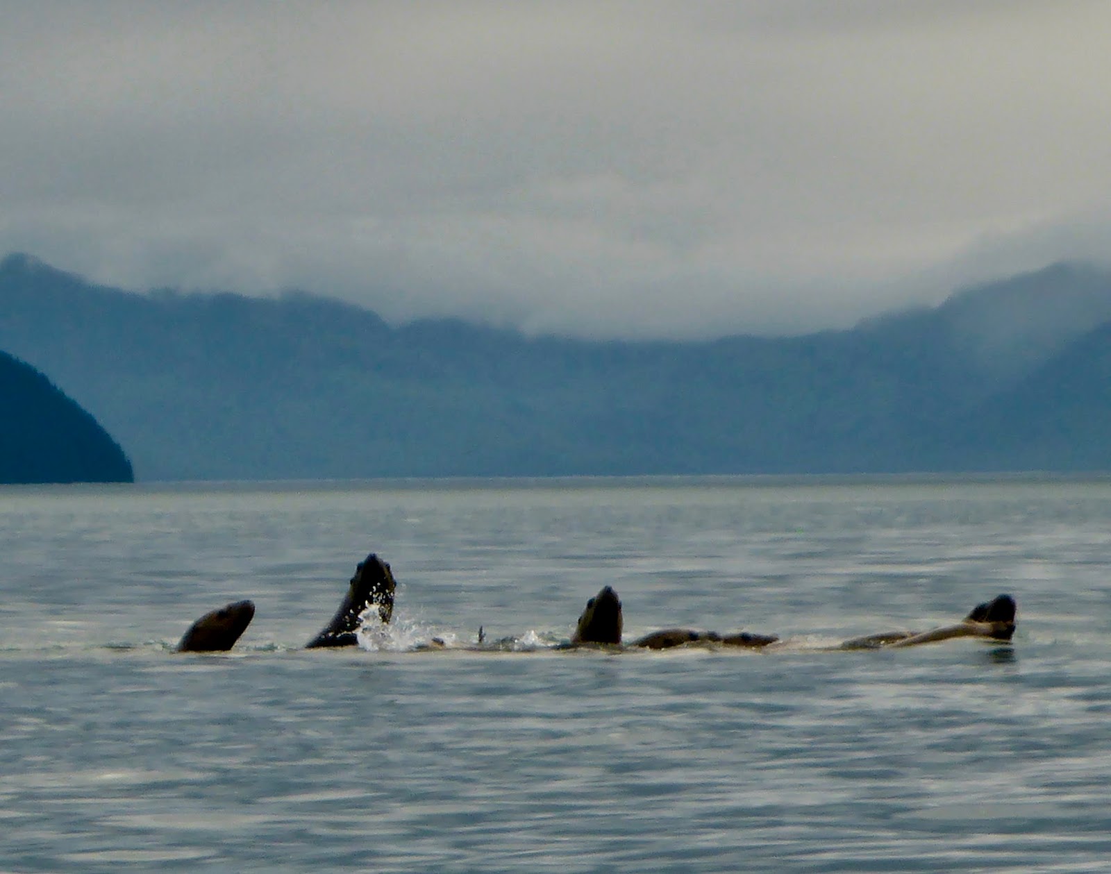
Our timing for the crossing of the mouth of Glacier Bay was fortuitous, right at slack. Along the way, we got lots of attention from a dozen or two sea lions, who played around us like puppies--maybe they thought we might have some fish for them? We got much less attention from the rafts of hundreds of sea otters, who dove before we could ever get very close. I often wonder if sea otters have evolved to be especially afraid of sea kayaks, which decimated their numbers during the Russian Alaskan period.
After the crossing, we began looking for a campsite, shortly finding a comfortable spot on a bench above the beach about 1.4 miles (statute miles) Southwest of Point Carolus, just West of a notable creek. Some bear sign, but not too bad, and wild strawberries! They never look ripe, but are very, very sweet. Cooked dinner and hit the hay early after an early morning and long traveling day.
Friday, November 24, 2017
2017 Inside Passage Route Waypoints
Put together a .gpx, .kml and .kmz file of campsites from this summer and other locations I found to be useful. Most of these I found through BC Marine Trails, Washington Water Trails, Kimantis, Dwyer, Miller and other common sources, but a few (especially in Alaska) are my own find (or Carl's or Emily's or Jason's!) finds. Files here.
Tuesday, August 15, 2017
Post-trip Thoughts on Routes
First off, I should admit that I'm generally an Alaska partisan, so my opinion should be taken with a grain of salt. That said, with a few exceptions, I found the landscape of the inside passage more striking, and the wildlife more numerous and impressive the farther North I paddled. Overall, I'm very glad to have done a more-or-less full transect of the inside passage route, in order to see what there was to see. If I had done a tour of Southeast Alaska, one of the ideas I contemplated early on in the planning process for my 2017 trip, I would have wondered was I was missing in Washington State and British Columbia. Still, if I had to do it all over again, and knowing what I know now, I would probably plan a longer trip in Alaska, possibly including some of the Northern portion of B.C. Though I would like to return to a few places I only saw from a distance, including Port Townsend, Victoria, and Anacortes, I'm not sure how interested I am in returning by kayak.
Much of the same goes for other parts of Southern B.C. I would return to Desolation Sound and the Lasqueti/Texada region, but I generally found the stretch from Desolation to Telegraph Cove a bit underwhelming, though my opinion might differ if Carl and I hadn't struggled so much with winds and tides.
On the other hand, I found the day or two before Port Hardy and the whole Cape Caution area compelling, if sometimes scary. I would love to go back and paddle more in that area. Beautiful country which really stretched my skills and increased my confidence.
North of Cape Caution, Carl and I decided to take a relatively direct route to and through Princess Royal and Grenville Channels. I would still love to see Hakai and Laredo Channel, among other areas, but I also didn't find the zone we did paddle all that interesting, though I thought Seaforth Channel and other areas immediately North of Bella Bella/Shearwater very beautiful.
The area around Prince Rupert also was lovely, and I would enjoy going back with more time to visit the Tsimshian communities there. Dixon Entrance treated me very well, and I think it would be a remarkable place to paddle under much more challenging conditions. I also really enjoyed Revillagigedo Channel and Clarence Strait. Ketchikan itself was not a strong draw for me, but then, I've been there many times before and have seen the sights.
Emily and I both enjoyed seeing Wrangell and Petersburg, but one day in each place is plenty!
The stretch between Petersburg and Juneau is really striking, and I definitely plan to return to both the mainland side of Stephens Passage (which I paddled) and the Admiralty Island side (which I have not). I would also like to do the connecting section between Juneau and Gustavus through Lynn Canal, Chatham Strait and Icy Strait, as well as the stretch from Juneau to Skagway up Lynn Canal, even though I have seen both stretches many times by ferry.
By far the best paddling of the summer was the last section I paddled--my second trip, from Gustavus to Sitka. The outer coast section is very, very beautiful--unrivaled by any other area I paddled this year. It also has more wildlife, and wildlife of a more impressive sort, than other areas. I have every intention of returning.
July 30, Snettisham Peninsula to Juneau (!)
What a day!
Managed to get out of camp, in the rain, at the usual time. Covered a fair amount of ground before about 4PM, paddling through a crowded gill net opener near beautiful Limestone Inlet, passing a bear near Point Styleman, and enjoying the beautiful scenery.
My objective for the day was Point Bishop, at the mouth of Taku Inlet, on the West/Juneau side, and I stopped for dinner at Suicide Cove, below Butler Peak, on the East side of Taku Inlet, then headed North, to cross over. I had initially planned to work my way several miles up the East side of the inlet before crossing, but began to get a bit of a tailwind as I headed Northwest, and decided to cut a bit of a corner and head directly for Point Bishop from Circle Point.
 |
| Paddling in. The light is me. |
When I arrived, it was still light, but although I had been fairly certain that I would find a beach to camp on, I was mistaken, and it would have taken a fair bit of backtracking--towards Point Bishop--to find a nice gravel beach. Instead of heading backwards, I figured I would continue up towards Juneau and stop (soon, I figured), when I arrived at a good camping spot.
 |
| Very happy to be home |
The paddling was a-ok. No wind, and almost completely calm water, with the exception of two slightly nervous moments dealing with big wakes, in the dark, from departing cruise ships. This was only the second time I had ever paddled after dark! It took another hour or so to paddle to Sheep Creek, but when I did, there she was, parked out on the tidal flats, ready to take me home. It was after 10 when I arrived, and was I ever thrilled to be there.
Monday, August 14, 2017
July 29, Point Windham to Snettisham Peninsula
 Another good paddling day with great mileage. Left camp late-morning (typical start for me) and paddled most of the morning to the Southeast side of Holkham Bay, where I grabbed a snack and took a short break. The crossing of Holkham Bay was especially beautiful, with good views up Tracy and Endicott Arms, and especially of the poetically named Sumdum Glacier.
 Grabbed water and ate dinner in a cove North of Point Coke; this might be a reasonable campsite, though I did not explore extensively. Then camped above a pretty beach on the Snettisham Peninsula, about half way between Holkham Bay and Port Snettisham, just to the Northeast of the Midway Islands.
Another solid mileage day, despite contrary currents (never did get a favorable current in Stephens Passage) and rain off and on all day.
Sunday, August 13, 2017
July 28, Point Walpole to Point Windham
 From the area of Point Fanshaw (several miles before point Walpole), I had to choose between several different route options that would get me to Juneau. The Western route would be a crossing over to Admiralty Island, home of the world's highest concentration of Coastal Brown Bears, then up through beautiful Seymour Canal, across to Stephens Passage at Oliver Inlet via an old rail tram, then across to Douglas Island to Juneau. This seems to be the standard route. A second option would be to cross to Admiralty, then, rather than heading up Seymour Canal, to head up the East side of the Glass Peninsula, up the West Side of Stephens Passage, then across to Douglas Island and to Juneau. The third option, which appears to be the least commonly taken, would be to travel up the mainland side of Stephens Passage. The attraction of this route would be (potentially) more striking coastline, with views up several long, steep fjords, including Tracy and Endicott Arms and Port Snettisham.
This last option is the one I chose. All three alternatives sounded fantastic, but it seemed more likely that I would make a trip down Seymour Canal and/or the East side of Glass some time in the future. The Southern end of Stephens Passage, though, is quite a long trip com Juneau, and I wasn't sure how long it might be before I could make it back.
 I was not disappointed. The scenery is unbelievable, and I was compensated for missing Admiralty bears by my earlier and later interactions with Brown Bears on Revillagigedo an Chichagoff.
In any event, the 28th was a day of crossings. Port Hougton, about four miles, Hobart Bay, about two miles, then Windham Bay, about three. The weather was again indecisive, with rain in the morning and evening an periodically through the day, but views up the three inlets were good and the scenery was very pretty. I thought the view up Windham Bay was particularly striking, and the rocky coastline was quite beautiful. Although I got little help from the flood current, the 28th was another solid mileage day.
July 27, Grand Point to Point Walpole
Another good mileage day, despite somewhat contrary tides. After a typically late start paddled down the remainder of Sumner Strait to Fanshaw Point, then turned North into Stephens Passage. Not much of note except for indecisive weather--it couldn't decide whether it wanted to rain or be sunny, making it difficult for me to decide what hat to wear and whether I wanted to wear sunglasses or not. The paddling was relatively fast, even though tides were against me most of the day and a predicted afternoon tailwind failed to materialize.
In the late afternoon, I took a break at the back of Fanshaw Bay for a snack and explored some of the site of a long-abandoned cannery; little remains, but interesting to see how quickly the forest has taken over what must have been a busy settlement forty or fifty years ago.
 My preferred daily paddling rhythm is a late afternoon start, a few relatively short breaks during the day, a break during which I eat and maybe cook dinner, then a few more hours of paddling before a relatively late stop (often 8:30 or 9) to make camp. My paddling partners generally prefer a more conventional schedule, so I usually follow along; typically, a slightly earlier start and earlier finish, with dinner in camp in the evening, but paddling alone (and also with Emily, who shares my preferences), dinner on the fly is the norm. In this case, I took a short break on a gravel beach on Foot Island to eat (didn't seem like a good place to camp anyways), then paddled on to Point Walpole, on a small island, unnamed on my chart (Walpole I?) with a beautiful gravel and clamshell beach, good upland camping and a lovely view in several directions. I paddled along with a pod of feeding humpback whales for the last several miles, and they also spent the whole night feeding in the area near camp--I could hear them spouting all night long.
July 24-26, Petersburg to Grand Point
Emily's ferry didn't leave Petersburg until the evening of the 25th, so we wound up having almost three days to enjoy the amenities of Petersburg. Good to finally see the place after living so close for so long, though we probably ha a pretty good feel for Petersburg after an afternoon. But we ate lots of pizza and seafood and enjoyed our last few days together before the next stretch of my trip.
On the 25th, we carried Emily's boat and gear over to the ferry terminal in the afternoon and checked her in for the ferry ride back to Juneau. The ferry arrived on time, and we said goodbye. Sad to see her go after a great two-ish weeks together.
Got up and got packed up the following morning, and ate breakfast at the B & B. It was a little tricky to get my boat down to the water by myself, but managed to get loaded and on the water by 9:30, just a bit before low slack, so I got a little bit of a push from the ebb current out of the Wrangell Narrows into Summer Strait. I made the crossing to the North side of the strait from the Sukoi/Sockeye Islands, basically so that I would pass close to some of the icebergs I could see floating on the Northern side of the strait. I had paddled by icebergs before a number of times, but it's always a striking sight.

Spent much of the day paddling down Sumner Strait against a flood tide, but Sumner has only a weak flood current and a substantial back eddy in many places, so made good progress before stopping at an attractive campsite with good beach and upland sites near Grand Point, on the Eastern side of Farragut Bay.
July 23, Iceberg View to Petersburg
Although we originally planned to arrive in Petersburg on the 24th, having left lots of time for short days towards the end of the Ketchikan to Petersburg leg, we made such good time on the 22nd that we decided to try to make it a day early, with the idea that we would be able to spend a little bit more time exploring Petersburg and eating the legendary Petersburg pizza.
 After a typical mid-morning start (late morning?) we were able to make it to Petersburg by early afternoon. At one point, close to town, we stopped for a break on a beach which would make an excellent campsite for a first or last night out, with good upland camping and a nice gravel landing beach, at least at high tide.
Once in cell range, we were able to make a phone call to out lodging, located next to the ferry terminal, and were able to add an extra night to our reservation.
The paddle into town was a trip--strong ebb tides out of Wrangell Narrows combined with lots of vessel traffic made for some high-intensity paddling. Throw in the sights and sounds of Petersburg's busy fish processing plants and the result was a little bit of culture shock after the serene wilderness paddling of many of the prior days and our mellow time in Wrangell. Cool place, though, and very true to it's Norwegian fishing town roots.
Getting in and out of town with a kayak is often a pain in the butt, but it was a little better in Petersburg than elsewhere--the ferry terminal has pretty good water access on either side of the terminal building, though we did have to carry our gear over some slippery kelp. From there, it was less than forty yards to the B and B.
The 23rd was a Sunday, and not much was open, but we were able to get some groceries and order a pizza from one of at least two local pizza joints. Studebaker's delivers, and comes with East Coast Pizza Snob Approval. Actually, both pizza places are solid options.
July 22, Wrangell through Dry Strait
 |
| Looking a little fuzzy and pretty well armed! LeConte Bay behind me. Dinner was macaroni and cheese. |
We had good luck on our crossing over to Mitkof, passing by Kadin island on the way. The relatively long crossing made Emily a little uncomfortable, combined with some wind and following seas, fog, and vessel traffic, but in the end, we had no problems and made it through Dry Strait just about on schedule.
In a way, the day was a little anticlimactic, since we saw no sign of gravel bars or mudflats on the delta, but we had very favorable tides all day and made good mileage. Also had some good wildlife sightings (harbor porpoises and whales). And once we were through Dry Strait, we could see icebergs floating out of LeConte bay, working their way down from the glacier.
Although the very high tides were helpful in our crossing of Dry Strait, they meant that we needed to find a good upland site--we had good luck in finding a site with a good view towards LeConte, with a nice gravel beach and water. We decided that the campsite was called "Iceberg View." The site would also have good beach camping at neap tides.
Tuesday, August 8, 2017
July 19-21, Berg Bay to Wrangell
Managed to make it through the night at Berg Bay without having our kayaks chewed on by bears, and we wanted to be out relatively early--even after our very long day on the 18th--in order to catch slack at The Narrows in Eastern Passage. The idea was to avoid any strong contrary currents, then ride a falling tide out towards Wrangell.
We were both dragging a bit, but made good progress towards Wrangell, and anyways, weren't due to arrive there until the following day. Mid-afternoon, made a great campsite find, located on a very small peninsula that would become an island at very high tides. Good campsite with flat ground on either side of the cobble tombolo connecting the islet with Wrangell Island.
The following day, the 20th, paddled a short 7 nautical miles around the Northern tip of Wrangell I., then south past the city harbor. Emily had reserved us a room for that night at a bed and breakfast located right on the beach, a bit south of the Wrangell Cemetery. We were met on the beach by the owner, who very kindly helped us unload and store our boats and gave us the lay of the land.
We spent two nights there, at the Grand View, enjoying town life for a bit and seeing the sites and enjoying the mellow ambiance of the center of the world.
We were both dragging a bit, but made good progress towards Wrangell, and anyways, weren't due to arrive there until the following day. Mid-afternoon, made a great campsite find, located on a very small peninsula that would become an island at very high tides. Good campsite with flat ground on either side of the cobble tombolo connecting the islet with Wrangell Island.
 |
| Eastern Passage from Wrangell Island, looking towards The Narrows and the Old Wrangell village site. |
The following day, the 20th, paddled a short 7 nautical miles around the Northern tip of Wrangell I., then south past the city harbor. Emily had reserved us a room for that night at a bed and breakfast located right on the beach, a bit south of the Wrangell Cemetery. We were met on the beach by the owner, who very kindly helped us unload and store our boats and gave us the lay of the land.
We spent two nights there, at the Grand View, enjoying town life for a bit and seeing the sites and enjoying the mellow ambiance of the center of the world.
Monday, August 7, 2017
July 18, Frosty Bay to Berg Bay
When we started the Ketchikan to Petersburg leg, I was concerned that our planned paddle from the Frosty Bay cabin to Berg Bay would be too long--22 nautical miles, or around 26 miles--given that Emily hadn't been paddling much over the summer. But in the end, it worked out very well, with a little bit of a tidal current assist.
After our moderate paddle the day before, we were able to get out fairly early in the morning (early for us, that is!). We made good time to a lunch break spot in a Cove South of Point Warde (would also be a good campsite, with a clamshell beach landing and good upland camping), then paddled on, with a few short breaks. Entering Bradfield Canal, then increasing as we paddled up Blake Channel, we started feeling a strong push from the tide. We stopped for an early dinner at Blake Island, and considered stopping and camping, but it was still early and the current was moving very swiftly in our direction, so we opted to continue.
The remainder of our paddle flew by, as glassy water, which nevertheless was flowing at three knots or so, carried us North to Berg Bay, for an arrival around 8PM. The last several miles were especially beautiful, with the mountains reflecting in the aquamarine water, with hardly a ripple.
 |
| Riding the tide into Berg Bay |
The remainder of our paddle flew by, as glassy water, which nevertheless was flowing at three knots or so, carried us North to Berg Bay, for an arrival around 8PM. The last several miles were especially beautiful, with the mountains reflecting in the aquamarine water, with hardly a ripple.
July 17, Vixen Point to Frosty Bay
 The 17th seemed like a long day--both of us were dragging. We had good paddling weather and mostly favorable tides, but it was a warm day, and the previous few had been pretty tiring for both of us.
Mostly pretty rocky shorelines on the route. Hard to find good break spots without going well out of our way, which might have helped to make the day seem longer.
As we paddled past Easterly Island, we watched and listened as two male sea lions with large harems grunted at one another from several hundred yards away at one another trying to attract females away from the other.
We arrived at the Frosty Bay cabin, where we spent the night, without too much trouble. The cabin is pretty and well kept, though it was posted with reminders to campers not to store food in the cabin; apparently bears had broken into another cabin closer to Ketchikan earlier in the summer in search of food.
Wednesday, August 2, 2017
July 16, Clear Cut to Vixen Point CS
After the somewhat fraught previous days, with our complicated start on the 14th with Emily's early morning Ketchikan arrival and early afternoon departure, and the challenging weather of the previous day, the 16th was a straightforward day with solid mileage.
 We got a late morning start (but earlier than previous days), and early on had another deer sighting, with four deer on the beach including two fawns. We considered stopping at Meyers Chuck, but ultimately decided just to wave as we passed, a little concerned about our schedule and anticipating long days to come.
We took a short break at "Daybreak" Cove, near Lemesurier Point, just North of Meyers Chuck. This small cove is not named on the map, but the stern of a wrecked vessel is located at the top of the gravel beach. The vessel's name, "Daybreak," is clearly visible. This cove would make for a pretty campsite at neaps, though the upland did not seem well suited to camping.
After turning East at Lemesurier Point, striking bare peaks East of Union Bay came into view. Our crossing of Union Bay was uneventful--about three nautical miles in around an hour. After the crossing, we stopped for dinner in a cove just South of Union Point, also filling up on water, then paddled on to a campsite near Vixen Point, several miles further to the East and North. As we neared Vixen Point, we had trouble spotting beaches for potential landing sites as the tide was quite high, but found a good with with nice upland camping a bit to the South of the point. There was some bear sign in this area--a small amount of scat on the beach and some tracks--but the scat seemed older and mostly evidence of bears just passing through; not a worry.
Finished off the day with a good view of a pretty sunset over Ernest Sound.
 We got a late morning start (but earlier than previous days), and early on had another deer sighting, with four deer on the beach including two fawns. We considered stopping at Meyers Chuck, but ultimately decided just to wave as we passed, a little concerned about our schedule and anticipating long days to come.
We took a short break at "Daybreak" Cove, near Lemesurier Point, just North of Meyers Chuck. This small cove is not named on the map, but the stern of a wrecked vessel is located at the top of the gravel beach. The vessel's name, "Daybreak," is clearly visible. This cove would make for a pretty campsite at neaps, though the upland did not seem well suited to camping.
 |
| Carl would have loved this one |
Finished off the day with a good view of a pretty sunset over Ernest Sound.
July 15, Caamano Point to Clearcut CS
Both a beautiful and challenging day.

We got a late start (even for me!) after our late arrival in camp the previous night. Great night's sleep, though, and we both felt much better than the day before, especially Emily, who was much better rested after a more-or-less normal night.
Had an amazing morning, with beautiful coastline and a long stretch where we paddled along with a pod of humpback whales bubble net feeding, as close as 50 yards away or less. Bubble net feeding, for you non-Alaskans, is an interesting cetacean behavior where a group of whales dive and cooperate to blow bubbles as they spiral to the surface together, driving food--fish--together where they can be easily swallowed. The bubble net behavior culminates with several whales lunging out of the water at the same time with their mouths open, then closing their mouths on (presumably) a school of fish. I've been told that this is a behavior that is only seen here in Southeast Alaska, though I don't know if that's true or not. We did our best to stay away from the whales, aware that legally we're not allowed to approach whales any closer than 100 yards, and also concerned about inadvertently winding up in a whale gullet, but several times the group surfaced near us; at moments like these, I have a difficult time estimating distance without exaggeration, but I would swear they surfaced no further than 30 yards from us at one point. Wild!

Although the weather was calm in the morning, after a lovely, sunny lunch at a pretty slot beach, we started to get a little bit of South wind in the early afternoon. The wind was never overpowering--and Southerlies were a favorable direction for us--but Clarence Straight is a body of water that runs in a North-South direction, and Southerlies can build up some relatively large waves over the length of the channel. As the afternoon went on, we started to experience waves that, though not dangerous, were enough to make Emily nervous--probably waves in the 2 to 2 and 1/2 foot range, with some reflection and refraction at different points.
After a particularly uncomfortable stretch rounding a rocky point, with complicated wave patterns, we decided to take an early dinner break in the hope that the weather would settle a bit. We made a dinner that I call Fancy Pants Mac & Cheese, ate, filtered some water, breaking for about two hours, then moved on after dinner, when the weather had settled enough to make paddling feel more comfortable for Emily.
Throughout the day, we stopped at a number of gravel beaches as we worked up the Cleveland Peninsula; good camping options in this area, with easy landings and often-accessible uplands. Water is also not in short supply.
Besides the whales, we also saw a black tail buck on the beach later in the afternoon, and passed a Black Bear, who we saw from a long way off, and who disappeared after he became aware of us.
The Northern section of the Cleveland Peninsula has been extensively logged, and as we began to near Meyers Chuck, we passed one very long clear cut strip that appeared to have been cut all about the same time, possibly as a single operation. The clear cut was a little unattractive, but a litoral buffer had been left uncut, and we found a nice campsite above the clear cut and below the beach a few miles South of Meyers Chuck. We camped on the beach, but there were small (lumpy) areas in the upland that would work as tent sites in a pinch. There was also water nearby.
Tuesday, July 25, 2017
July 14, Ketchikan to near Caamano Point
 |
| Getting ready to roll! |
Even so, it was such a wonderful treat to finally meet up with my beautiful wife Emily on the 14th, after having been apart for about two months. She arrived at 3:30 in the morning on the M/V Matanuska, one of Alaska's larger ferries. Initially, my plan was to meet her at the ferry terminal to help her carry her kayak off, then take a taxi back to the hotel, where we would launch, but oddly, I was unable to find a taxi company that would carry us and the kayak. In the end, I wound up renting a car briefly to get the job done--a little hit to the wallet, but not too bad.
After the very early arrival, we both were happy to get a short nap, then eat the hotel breakfast. This, followed by a late checkout and an early afternoon launch. Very early on, we spotted a pod of whales, maybe a dozen. More than I had seen through the whole trip so far!
 |
| One of us is looking pretty fuzzy! |
Despite the late start, we made it to Point Higgins for an early dinner--breakfast burritos for us--which we enjoyed in the sun. This area really should make a lovely kayak campsite, through it is bordered by private land on homes several hundred yards away on both sides. There is a creek for water, and good beach and upland tentsites. The landing is very good. Though campers might have to share their Alaskan paradise with the occasional jogger and dog walker.
Although Emily was tired by this point, the water in Behm Canal looked very calm, and we finished our dinner around seven, giving us a few hours to do the crossing. She was a little ambivalent, but ultimately decided that we should go for it, no doubt after my first-class bullshit artistry kicked in, trying to convince her that (as I thought) a crossing that evening was the safest and most sensible choice. The crossing took us a bit longer than I expected, and Emily was a bit uncomfortable so far from land, but we were able to watch a first class sunset on the way, and arrived at a good campsite on an island Southeast of Caamano Point with enough time to set up camp and set a bear bag (necessary our first night or two).
The campsite itself was above a narrow gravel beach tucked into the rocky shore on the island Southeast of Caamano Point. The landing is a bit rocky, with kelp, at very low tides. No water there, but very comfortable upland tentsites. The lights of Ketchikan were visible across the canal, but we were already out of cell coverage.
Very, very good to be with Emily!
July 12-13, Cone Point to Ketchikan
Quite an eventful day!
After my long, high-mileage day on the 11th, had a bit of a slow morning, with a late breakfast and departure. While eating my morning cream of wheat, watched a big Brown Bear amble out on to the beach a few dozen feet from me. Beautiful! And not a little scary. Just about the best possible kind of bear encounter, though. I got a good look, shouted "Hey Bear," and she was gone.
Later, in hearing about it, Emily worriedly suggested that maybe I should be listening to music or podcasts in camp in order to make more noise and warn any nearby bears of my presence. I told her that at that moment, I was listening to Slate's "The Gist." Her reply was something along the lines of, "Well, Mike Pesca is probably the best thing I can think of to keep the bears away," although we both wondered if the Trumpcast or Political Gabfest might be more frightening to ursine neighbors.
An hour or two later, I was on the water, making good progress towards Ketchikan. I wasn't due to meet Emily until the 14th, so didn't really have any reason to be in town until the 13th at the earliest. However, I had made such good time the previous days, and was being carried along so quickly by the wind and tides that an early arrival was possible, which I figured would give me a little extra time to do things like laundry, and would give me a chance to visit the post office to ship now-unnecessary charts home.
The only hitch was that I would need to clear customs immediately upon landing in Ketchikan, and the customs post closed at six, which would make my afternoon paddle a little bit of a race. I had called the US customs post in Ketchikan from Prince Rupert, and they assured me that they could clear me at any time, but it sounded as if it would be a bit of a pain in the rear if I arrived after they had closed for the day. I was undecided, and so pulled out briefly on the Northern end of Annette Island, where I figured I would get cell reception, and called Emily to ask her advice.
Emily thought I should go for it, and agreed to make me a reservation for that night. Great! Although I did manage to drop my phone in shallow water during the call. Thankfully, I have a more-or-less waterproof case, and the phone came out all right.
Then, after I had decided to race into downtown Ketchikan, as I was pushing off, I broke my Greenland paddle on one end of the loom. Curses! I started the trip a little ambivalent about that paddle, but by this time, it had become my favorite. I miss that thing! Thoughts immediately ran to how quickly I could build a new one once the trip was over, and how I would improve on the first. A shame that it snapped, but a successful experiment, to be sure!
In the end, I made it to the Ketchikan harbor by creek street with time to spare, and my customs clearance was hilariously informal. Mostly consisted of me telling stories about my trip to a mildly incredulous customs agent. The only formality was a brief showing of the passport.
As I was paddling through the harbor, received an offer from the kayaking guide firm located near the harbor entrance to store my kayak on their float while I was in town--no doubt a secure place. And they recommended the youth hostel, several blocks uphill, as a place to stay. But I already had my reservation, and a few more miles to paddle, on glassy-calm waters, with very little vessel traffic. Though at one point I was a little concerned that I was about to be run down by an incoming DeHavilland Otter.
Made it to the lodging by half past eight, and checked in. Comfort food at the restaurant, comfortable room and a good night's sleep! Then laundry, the post office, and some fast food the next day. A good early stop.
After my long, high-mileage day on the 11th, had a bit of a slow morning, with a late breakfast and departure. While eating my morning cream of wheat, watched a big Brown Bear amble out on to the beach a few dozen feet from me. Beautiful! And not a little scary. Just about the best possible kind of bear encounter, though. I got a good look, shouted "Hey Bear," and she was gone.
Later, in hearing about it, Emily worriedly suggested that maybe I should be listening to music or podcasts in camp in order to make more noise and warn any nearby bears of my presence. I told her that at that moment, I was listening to Slate's "The Gist." Her reply was something along the lines of, "Well, Mike Pesca is probably the best thing I can think of to keep the bears away," although we both wondered if the Trumpcast or Political Gabfest might be more frightening to ursine neighbors.
 |
| I miss that paddle |
An hour or two later, I was on the water, making good progress towards Ketchikan. I wasn't due to meet Emily until the 14th, so didn't really have any reason to be in town until the 13th at the earliest. However, I had made such good time the previous days, and was being carried along so quickly by the wind and tides that an early arrival was possible, which I figured would give me a little extra time to do things like laundry, and would give me a chance to visit the post office to ship now-unnecessary charts home.
The only hitch was that I would need to clear customs immediately upon landing in Ketchikan, and the customs post closed at six, which would make my afternoon paddle a little bit of a race. I had called the US customs post in Ketchikan from Prince Rupert, and they assured me that they could clear me at any time, but it sounded as if it would be a bit of a pain in the rear if I arrived after they had closed for the day. I was undecided, and so pulled out briefly on the Northern end of Annette Island, where I figured I would get cell reception, and called Emily to ask her advice.
Emily thought I should go for it, and agreed to make me a reservation for that night. Great! Although I did manage to drop my phone in shallow water during the call. Thankfully, I have a more-or-less waterproof case, and the phone came out all right.
Then, after I had decided to race into downtown Ketchikan, as I was pushing off, I broke my Greenland paddle on one end of the loom. Curses! I started the trip a little ambivalent about that paddle, but by this time, it had become my favorite. I miss that thing! Thoughts immediately ran to how quickly I could build a new one once the trip was over, and how I would improve on the first. A shame that it snapped, but a successful experiment, to be sure!
In the end, I made it to the Ketchikan harbor by creek street with time to spare, and my customs clearance was hilariously informal. Mostly consisted of me telling stories about my trip to a mildly incredulous customs agent. The only formality was a brief showing of the passport.
As I was paddling through the harbor, received an offer from the kayaking guide firm located near the harbor entrance to store my kayak on their float while I was in town--no doubt a secure place. And they recommended the youth hostel, several blocks uphill, as a place to stay. But I already had my reservation, and a few more miles to paddle, on glassy-calm waters, with very little vessel traffic. Though at one point I was a little concerned that I was about to be run down by an incoming DeHavilland Otter.
Made it to the lodging by half past eight, and checked in. Comfort food at the restaurant, comfortable room and a good night's sleep! Then laundry, the post office, and some fast food the next day. A good early stop.
Monday, July 24, 2017
July 11, DeLong Islands to Cone Point
One of my less comfortable days, at least for a couple of hours.
After a very nice night in the DeLong Islands, got a mid-morning start, first with very little wind, then with a bit of a Southerly tailwind.
Very smoothly made the first couple of miles, past Kah Shakes Cove and Boca de Quadra. As I approached the big-ish crossing of Behm Canal (or rather, the first crossing), rain started to fall on and off, and some foggy patches that had been off in the distance started to move in. One strategy might have been to work my way a few miles up Behm Canal to a place where the crossing to Revillagigedo Island was a little shorter, but I felt like I had a pretty good compass read on where I was heading, and conditions were very good; I decided to go for it and make the crossing, starting just North of Black Island. For those of you not carefully following along with a nautical chart in hand, this means that my crossing was probably something in the order of five nautical miles--not the biggest one I've done, by any means, but no trivial distance, either.
In general, the crossing went fine, but as I progressed towards Revilla, the Southerly wind started to pick up, really moving me along at a pretty good pace, and at the same time, the fog started shifting in, blocking my view of Point Alava, my target. As I worked my way across, the wind waves coming up the channel got bigger and bigger--at times probably approaching five feet, well over my head, and as I neared the shore, I started to feel the effects of waves reflecting and refracting off the shore, which is quite rocky through that stretch. These were no Cape Caution swells, but these steep wind waves were tiring!
 |
| Pulling out in the DeLong Islands |
By the time I was within striking distance of land, I was starting to get a little nervous, was definitely in need of a break, and wind waves were starting to break around me as they met and interacted with waves bouncing back off the shore. Trouble was, the shoreline was too rocky to land under those conditions, and because of the wind and fog, I wasn't exactly sure where I was along the Revillagigedo shoreline. I rounded several rocky points, each time hoping for a gravel or sandy beach to pull out on around the other side, but each time, no luck.
Several hours after I started my crossing, I found myself in a location where I thought I might be able to squeeze between a sheer headland and a rocky islet to get into what appeared to be more protected waters beyond, but by this time, the number of whitecaps made it difficult to tell if the passage was safe or would be lined with kayak-wrecking, shallowly submerged rocks. By this time, I was getting a little desperate for a stop and a pee. After a minute of watching, I decided that I could make it, and shot my way through into clearer waters. And not a moment too soon! The dropping tide was about to uncover a sandbar that would have very shortly made it difficult for me to get through.
After a moment with the chart and the GPS, I confirmed that I was in Lucky Cove. Lucky for me! The cove was well protected from the Southeast, and very calm. It also had a creek where I could find water and several excellent campsites. I considered stopping for the night, but despite my jangly nerves, it was still relatively early and I could pack in a few more miles before finishing fairly easily. I filtered several liters of water, and looked out at Revillagigedo Channel, wondering if things looked a little calmer out there, and examined some bear scat, wondering whether that suggested that I should be moving on.
Ultimately, I decided that I should paddle out towards the Western end of the cove and out into the channel to see if it was more practicable. If not, I could turn around and come back, or stop at another campsite, should a good one appear along the way. When I got out into the channel, however, things were much better, and I was able to progress several miles further without much trouble, to a known campsite near Cone Point, just East of Thorne Arm. The site is a peninsula except at very high tides, when it becomes an island, and has a lovely gravel landing beach and level, soft tent sites. It also has a number of culturally modified trees, which always make me feel like I'm in a very old place.
By this time, it was quite late, and I made dinner in the dark. There was also a little bear sign in the site--none very recent--but I made sure I was well armed with my various anti-bear implements, and turned in for a very restful night of sleep.
Sunday, July 23, 2017
July 10, Sitklan Island to the Delong Islands
My first full day paddling in Alaska was really lovely--one of my best so far--though that may be my pro-Alaska bias showing. Got a relatively early start and headed out around Garnet Point, at the Southern tip of Kananganut Island. From there on, I passed gillnetter after gillnetter, one after the other, often no more than a few hundred yards apart, as I worked my way up Revillagigedo Channel.
I crossed Nakat Bay from Garnet Point across to Cape Fox, stopping briefly for a snack and some coffee in the Lord Islands. There, I pulled out on a beautiful clamshell beach, disturbing some nearby seals in the process. I was a little embarrassed to drive them off the beach, but as I glided into shore, I could see smaller seals--presumably, curious teenagers--swimming towards my kayak underwater, visible against the white beach sand underwater. I sat for several minutes, watching them swim towards me, then turn around and swim back to the safety of some nearby rocks. Eventually, a few were brave enough to swim directly under the kayak, no more than a few feet away. Cool! Better than watching them at the Seattle Aquarium!
 After finishing the crossing at Cape Fox, I paddled up the mainland shore for several hours, enjoying beautiful paddling weather (that is, overcast and calm) and a favorable tide. Stopped briefly near the Tree Point light, with several old structures in evidence from when the lighthouse was still staffed. It appeared to me that it might be possible to enter the lighthouse on the ground floor and even maybe camp inside, though I didn't investigate any more closely than a long glance from my kayak.
That afternoon, made good progress, and ultimately decided to call it a day in the DeLong Islands, where I had a record of a known campsite. Was able to find another pretty clamshell beach, complete with a driftwood shelter built by an earlier kayaker. Rain was in the forecast, so I set my tarp over the driftwood shelter for a more comfortable evening and breakfast in the morning. There was also a very comfortable upland site just behind the beach. Certainly one of my best campsites of the trip.
 |
| Kitchen on the beach in the DeLong Islands |

That afternoon, made good progress, and ultimately decided to call it a day in the DeLong Islands, where I had a record of a known campsite. Was able to find another pretty clamshell beach, complete with a driftwood shelter built by an earlier kayaker. Rain was in the forecast, so I set my tarp over the driftwood shelter for a more comfortable evening and breakfast in the morning. There was also a very comfortable upland site just behind the beach. Certainly one of my best campsites of the trip.
Subscribe to:
Posts (Atom)